Tags
from planning my very first route in 2016 to today, the comfort provided by tools such as komoot or ride with gps had been extremely enhanced over the recent years. My absolute favorite tool by far the setting up my route is komoot.
Announcement
When a new edition of a TCR is being announced, the Lostdot team provides the start, the finish and the check points in between. This gives a very rough and first impression to everyone what is going to be on the menu.

Race manual and parcours
There is going to be a race manual provided to the selected riders for the upcoming race. This manual will receive some updates during the planning process and feedback from riders towards Lostdot. At that time it is also already clear that there are defined parcours around each check point. Usually these sections are provided as gpx files via ridewithgps. At that time your planning can already be quite precise and you can get a good feeling for where you plan to ride.

Banned roads
During my planning process, the information of banned roads is going to be published to the riders. If you ride regularly you can start your planning based on last years information as these information grow from race to race. Banned roads are prohibited for riders, not necessarily because they are officially banned but because they are dangerous. Also tunnels may be part of this banned roads data, provided by google.
Having collected all these information into your planning tool or system and also into your brain is already quite an effort. the update of the banned roads have a strong potential of destroying intensive planning steps that have consumed tons of time. I ignored these limitations for quite a while to set up my options and strategies how to get through Europe, which countries shall be part of my planning. To be honest, my expectations of cycling through Montenegro had been strongly minimized by the facts of banned roads.

Options over options over options
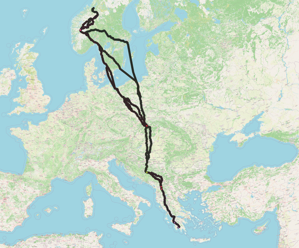
For sure there may be the one perfect solution for getting from Trondheim to Kalamata on a bicycle. My preferences for cycling are probably different to the ones of others. Options may result from your very own preferences and requirements. The crossing of the Baltic Sea may become an early strategical or tactical maneuver. There are some ports along the Northern Coast of the Baltic Sea. Which port to choose, maybe you gonna have a look at the schedules before you leave. Some ports offer connections several times a day, other ports only every other day. This section of crossing the water will definitely affect the race itself. Also there are some hints in the race manual where it is allowed to cross the Baltic Sea.
Making decisions on my sections
Getting back from a cloud full of options back to an amount of options that can be handled until the race begins or maybe a particular location on your route is a challenge as I have to weigh in all collected information. My strong recommendation to make as many decisions at home during your planning that shifting these to the moment when you are out on the bike. There are so many decisions to be made every day that you are happy for any major decision that it has been made already before.
Not every decision may turn out as right or good decision, this is a kind of risk mitigation for letting you ride your race after it began. There will be enough detours due to blocked roads, severe weathers, or …

My decisions are made
This is my preferred route. On this route there is one point on Swedish roads when I have to decided whether I head towards Trelleborg/Ystad or towards Stockholm. I am planning not to enter Germany, we will see how this is going to work out.

Additional information – shelter
Other than before the start or after the finish, I never booked a bed or a room, I always slept outside. You can say this is one of my major long distance rules. There was only one exception, when I cycled together with my wife.
I collected some data from openstreetmap for shelter close to my preferred route, this may help me to quickly find a spot for a rest. This concept is based on resting a night. This concept may receive a heavy modification when the heat is coming in the temperatures during the day climb up too high. Then cycling from later afternoon to almost noon may take place. We will see. As I mentioned before, heat has my greatest respect of all interferences.

Additional information – water
Finding fresh water will be a challenge, for cooling the system back down and for drinking. The kidneys must function well during all this time, not drinking enough is my greatest risk of all. In German we have the word “Hunger-Ast”, hitting the wall is terrible also, but lacking of water is my greatest fear. That is why I added an additional info-layer to my water point of interest (POI).

Additional information – cemetery
Cemeteries in many countries offer a water supply to people caring their graves. Cemeteries have helped me a lot in Germany and France. In Croatia, Bosnia&Herzegovina and Serbia, cemeteries are mostly equipped with plastic flowers. The clear indication that you do not need to stop for checking whether there was a hidden hose, somewhere.

When all your plannings are done, everything that needs to be clarified is how to get to the starting line. After two or three weeks there may occur another, a final challenge: how to get back home. During the first and long races I enjoyed the comfort of air transportation as well. During the last years I reduced my options of travelling to ferry, train, bus and taxi. So there will be another adventure after reaching the finish line. Any scratching during the race will make a return back home easier than from the furthest away point: Kalamata.

